Sunday afternoon
Flash of color in the sky
Nature’s double gift


Once we had seen what we wanted at the Hoover Dam, we headed towards our next destination, Route 66. Route 66, the “Mother Road”, was one of the original US highways. It was established in 1926 and stretched from Chicago, IL through Missouri, Kansas, Oklahoma, Texas, New Mexico and Arizona finally ending in Santa Monica, California for a total of 2448 miles. It was a major route for those migrating west during the Dust Bowl of the 1930s. For more information, click here.
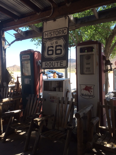
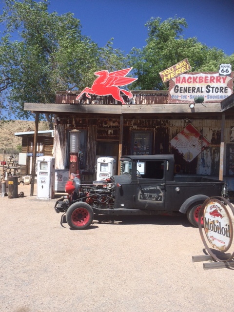
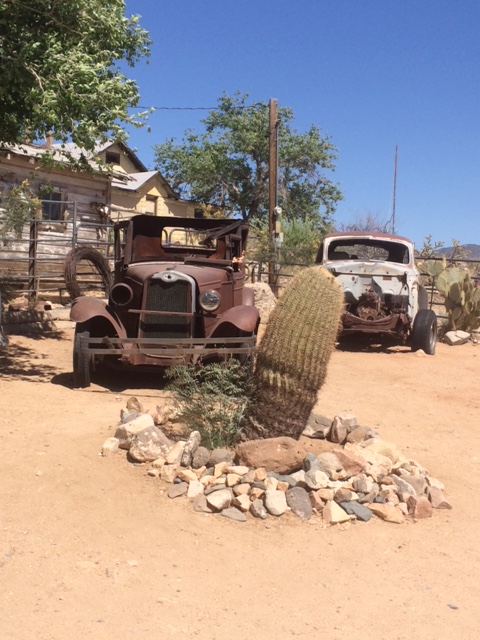
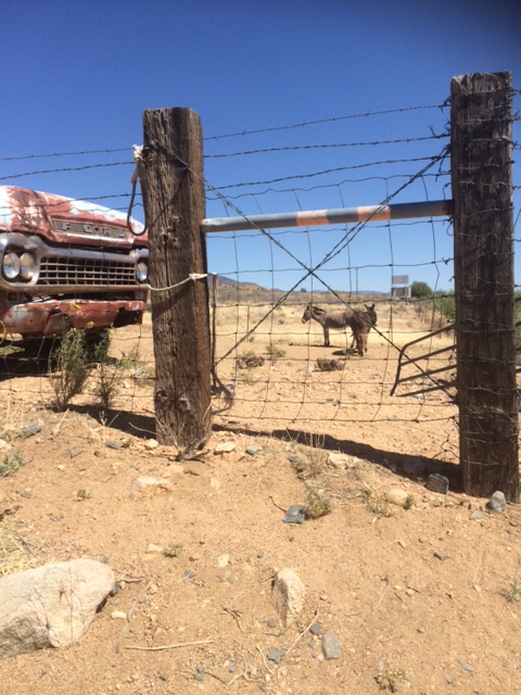
Our first stop along the Mother Road was Hackberry General Store in Hackberry, Arizona. Historically, Hackberry was a small town of ranchers and miners. Today, it is a vintage museum offering a wealth of memorabilia for Route 66, and is a popular spot for tourists and bikers traveling the road. It was an awesome place to take pictures. We went inside the store and found a vintage diner display, a gift shop and an assortment of snacks and beverages. I was able to purchase 3 postcards for $1 which I thought was an amazing price.
After Hackberry, we drove 60 more miles to Seligman, Arizona. Seligman is a small town that was part of the original Route 66 from 1926-1978, but it was eventually bypassed by Interstate 40. It was also a site along Beale’s Wagon Road and the Santa Fe Railroad. Angel Delgadillo, a resident, barber and founder of the Historic Route 66 Association, has stated that traffic to Seligman pretty much disappeared with the opening of I-40. When we arrived, it was late in the day and many shops were closed, however, we were able to walk around Angel and Vilma’s Original Route 66 Gift Shop then we ate a delicious dinner at Lilo’s Cafe, an American-German restaurant.
With full bellies, we headed on to Williams, Arizona to rest up for the night before heading to the Grand Canyon the next day.
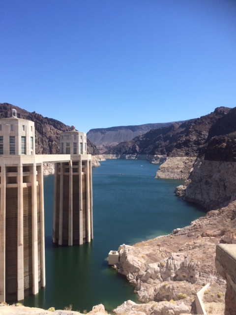
After a brief stay in Las Vegas, we hit the road to drive 33 miles to the Hoover Dam. We had rented a car at the airport in Vegas because we wanted to see some sites along the way to Los Angeles. The Hoover Dam, located on the border of Nevada and Arizona, does not have a street address. For driving directions and GPS coordinates, click here.
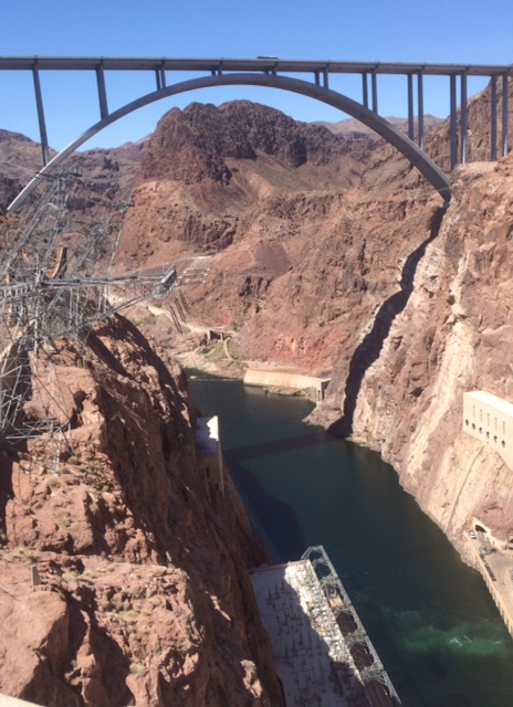
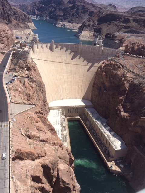
The Hoover Dam was built between 1931-1936 during the Great Depression. As the southwest began to develop, it was built to divert the Colorado river in an effort to control the flow of water, provide power and for irrigation purposes. Today, it provides water and hydroelectric power to over 20 million people and to farmland in Nevada, Arizona and California. It forms Lake Mead which is the largest reservoir in the United States in terms of volume. Originally named the Boulder Dam, it was renamed the Hoover Dam for President Herbert Hoover.
Some interesting facts about the Hoover Dam:
The Hoover Dam is considered an engineering wonder and there are several lookouts around the dam for viewing. It is definitely worth a visit, but if you go, hold on to your hat. I found it to be quite windy and almost lost my hat a few times!
Last summer, my kid sister moved to Los Angeles to work in the film industry. After several months of not seeing her, I decided to schedule a trip, along with another family member, to visit her in LA. As we planned the visit, we decided that we also wanted to see the Hoover Dam, the Grand Canyon and part of Route 66 so our trip expanded into something even bigger which I think of as the “wild west” excursion. We began and ended our adventure in Las Vegas since Vegas is centrally located between the Grand Canyon and Los Angeles.
Las Vegas
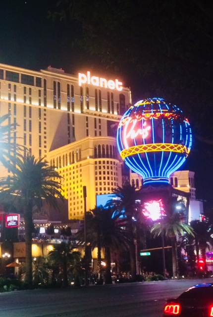
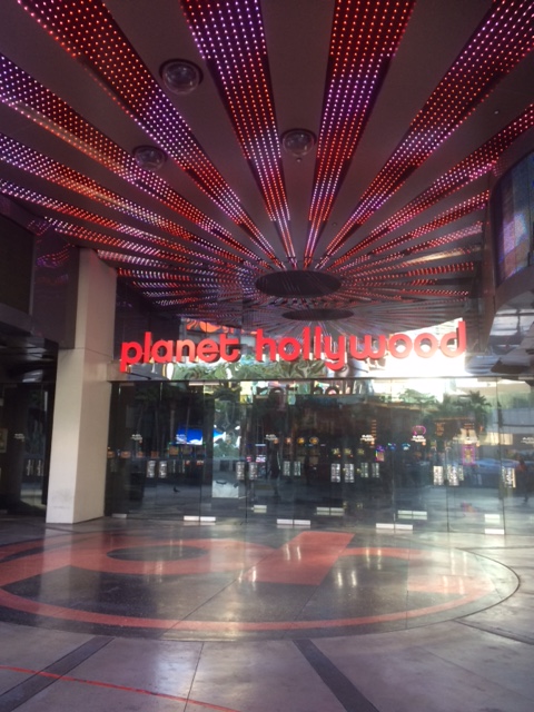
Although Las Vegas was more of a connector city for us on this trip, we still had a little time to explore it. We flew into Vegas and stayed there our first evening before heading to the Hoover Dam the following day. After a little research, we booked a room at Planet Hollywood and couldn’t have been happier. For approximately $100 which we split (depending on the night, you can pay even less), we stayed in a super spacious room with two queen sized beds and a large bathroom containing two sinks, a large tub and a separate shower. Planet Hollywood offers both valet parking and free parking at the Miracle Mile shopping center which connects to the hotel. In order to save money for the rest of our trip we parked ourselves, but be aware that the hike to the hotel can be long when you self-park since you have to carry your bags through Miracle Mile to reach the hotel. The hotel contains a casino and several restaurants in addition to 2,567 rooms (!) and the Zappos theater which has hosted the likes of J-Lo, the Backstreet Boys, Lionel Richie and more.
After hiking to the hotel and oohing and ahhing over our room, we headed downstairs to grab a bite to eat at the Earl of Sandwich restaurant. It was pretty good except that Earl of Sandwich has this weird combination beverage of earl grey tea and lemonade, in keeping with the theme I’m sure. I like tea and lemonade but earl grey tea with it’s unique taste has no place near lemonade in my humble opinion. No big deal. I just poured it out and got something else. If we had wanted to make more of an evening out of our meal, Gordon Ramsay also has a couple of restaurants in and around the hotel.
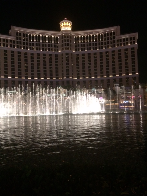
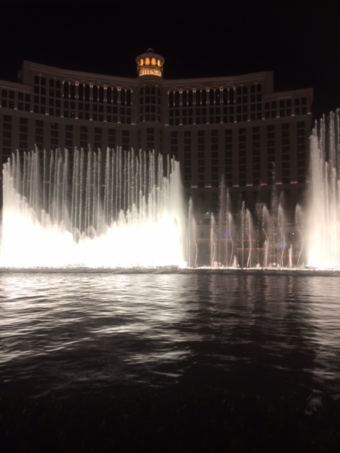
Afterwards, we hit the Vegas strip (Planet Hollywood is right in the middle of things) and walked down to the Mirage hotel to see their free show of a simulated erupting volcano which happens three times a night at 7, 8 and 9 pm. Click here for a Youtube video. After the erupting volcano, we walked to the the Bellagio for their free water fountain show, a personal favorite of mine. Here is a video of the fountain show to the tune of “Luck be a Lady” by Frank Sinatra. The fountains perform every half-hour from 3-8 pm and every 15 minutes from 8pm-midnight.
A little history of Las Vegas:
Las Vegas acquired its name in 1821 from Rafael Rivera who was a member of a trading party that was stopping for water on the way to Los Angeles (guess we were not the only ones to use Las Vegas as a connector city). At that time, the area contained several artesian wells and was surrounded by green areas, believe it or not. The name Las Vegas actually means “meadows” in Spanish. Urbanization began in Las Vegas in 1902. In 1931, when construction began on the Boulder Dam (now the Hoover Dam), the Mafia built the casinos and showgirl theatres to entertain young males who were drawn to the city when they moved in to work on the Hoover Dam. Electricity from the dam allowed for the building of additional hotels. In 1966, American businessman Howard Hughes arrived in Vegas. His presence tempered the effect of the Mafia as he worked to change the image of Vegas to make it more glamorous. He is credited with turning it into a more touristy area. The 1960’s was also the heyday for one version of the famed “Rat Pack”, a group of entertainers (Frank Sinatra, Dean Martin, Sammie Davis Jr. and more) who were centered around the casinos. By the 1980s, the effect of the Mafia died out, in part to the aging population of the World War II generation and in part to a drop in organized crime. Beginning around 1989, Vegas became more of a mega-resort area and today most of the hotels are owned by mega-corporations. For more information, see this article on the history of Las Vegas.
We enjoyed our brief time in Vegas, but after after strolling around for a while, we retired to our room to rest up for an early start to our next destination, the Hoover Dam.
Recently, I came across this picture of Symmes Chapel aka “Pretty Place”. I think it is one of the most beautiful chapels I’ve seen, at least judging by the photo, and I can’t wait to visit it someday (very soon, I hope).
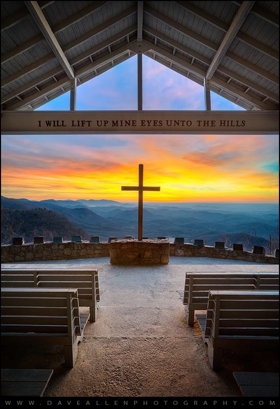
I did a little research on Pretty Place and found that it is located in a very small portion of South Carolina that lies within the Blue Ridge Mountains. Constructed in 1941, it sits on the property of the YMCA Camp Greenville. Mr. Fred W. Symmes donated the chapel for the enjoyment of children who camp at the YMCA during the summer, but visitors are welcome to visit the chapel during daylight hours and the chapel can even be booked for special events like weddings.
If you’re interested in seeing a schedule for the chapel, click here or you can call ahead at: (864) 836-3291.
I know that this is one destination that has found a spot on my bucket list.
Happy Easter, all!
It’s been a while since I’ve written about an excursion. Things have been complicated lately, and other thoughts and concerns have presented distractions. That’s ok. Life happens. But this morning when I got up and saw the sun shining on a beautiful day, I decided that it was time to go exploring. I called one of my favorite sidekicks, and started the conversation like I often do, “I know it’s late notice, and it’s fine if you’re not interested but…” About two hours later, we were on our way to Hammocks Beach State Park near Swansboro, NC.
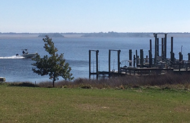
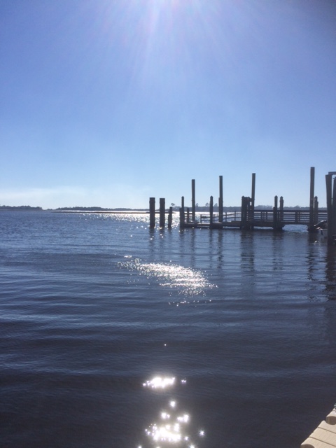
Hammocks Beach consists of 1520 acres. It includes a mainland area that offers a visitors center, lookouts, a launch site for canoes, kayaks and ferries and a hiking trail. It also consists of four barrier islands: Bear Island, Huggins Island, Dudley Island and Jones Island which are accessible by ferry or private boat. Bear Island is the biggest attraction of the four. It is 4 miles long, has a south facing beach and contains hiking trails, as well.
The history of Hammocks Beach is an interesting one. Originally, it was inhabited by Native Americans. Once the Native Americans migrated northward, pirates moved in and roamed the waters and the islands around the park. During the Civil War, Confederate soldiers used Bear and Huggins Islands to defend the mainland and during WWII, the Coast Guard used the area to monitor for German U-boats. In the early 20th century, the island was acquired by a neurosurgeon from New York named Dr. William Sharpe who willed it to the NC Teachers Association, an organization of African American Teachers. In 1961, they donated the park to the state of North Carolina. Originally intended as a park for minorities, the park was opened to everyone after the Civil Rights Act in 1964.
(Source: https://en.wikipedia.org/wiki/Hammocks_Beach_State_Park)
Since we were at Hammocks Beach Park during the off-season, my friend and I were unable to take the ferry over to Bear Island. We stayed on the mainland, strolled around the museum in the visitors center and went to the lookouts on the grounds. We found the hiking trail but a controlled burn prevented us from walking the entire length of the trail.
We turned our sights to downtown Swansboro which was only about 8 minutes away, and found a restaurant close to the water named Boro. I had delicious Brazilian chicken in a tomato basil wrap with sweet potato fries and slaw. My friend had a burger and fries. The price was pretty affordable as we both paid about $11 and some change for lunch.
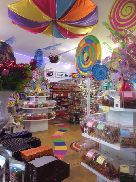
Afterwards, we walked the length of Front St where the restaurant was located. Quaint shops lined the street along the water. We found a candy shop called Candy Edventure and I bought some peanut butter chocolate fudge.
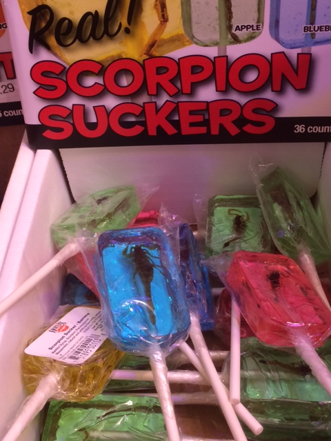
They also sold scorpion suckers…
and ant suckers…
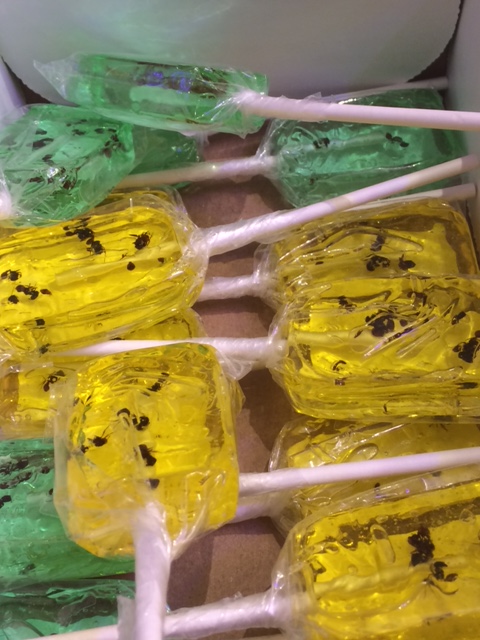
but I opted not to try those. (I can’t think why) (Eww).
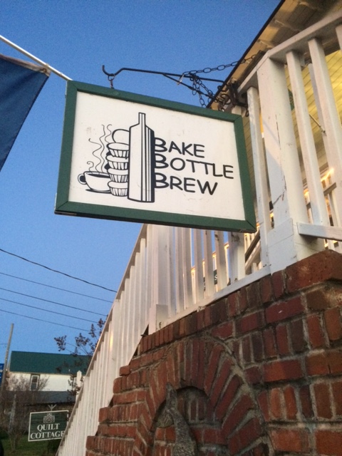
With fudge in hand, we strolled back up the street and slipped into a coffee shop/bar named Bake, Bottle & Brew. I figured that a cup of coffee would go really well with my dessert. It ended up being my favorite place on that little strip.
With our bellies full and our sense of adventure satisfied, we headed home. I’m thinking that I may go back during the summer to see what those places are like during the busy season, but I really enjoyed hanging out there today while everything was kind of quiet, too.
Until next time..:)
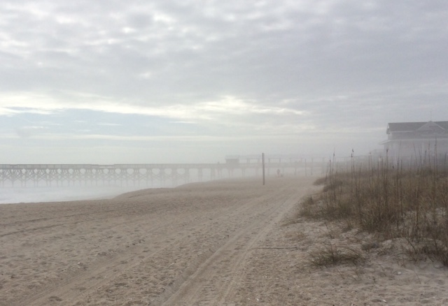
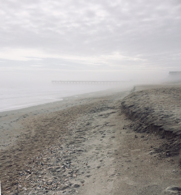
One day last week, I visited the beach on my lunch break. It was just a day or so after a snow. The snow had melted, but I was treated to a misty midday fog by the ocean. There were only a few other souls out there, a sharp contrast to the crowds of summer. They, like me, were wrapped up in their scarves and coats, braving the cold just to be near the water. I could not see them til I was right up on them, and as soon as we exchanged polite nods, if that, we faded from one another’s views as the mist enveloped us. I felt as if I had the beach to myself as I walked along in silence through the fog.
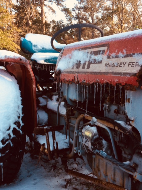
This past week, we had a rare snowfall on the coast of North Carolina. While visiting family, I noticed their tractors covered in snow out in the yard. I liked the look of them so I went outside to take some pictures. I got the photo below of a weathered Massey Ferguson belonging to my step-dad. Just one of the many ways I enjoyed our snow days.
chamomile tea with
honey fills my evening
mug as the snow melts
